
- Видео 133
- Просмотров 23 767 978
Indiana Drones
США
Добавлен 27 сен 2019
Welcome to Indiana Drones - Your Gateway to the World of Drone LiDAR!
As your premier source for all things drone LiDAR, we strive to bring you valuable content that sparks your passion for flying and fosters a community of fellow enthusiasts. Hit that subscribe button and join the Indiana Drones family!
Explore the world of Drone LiDAR from a new perspective, capturing real life use cases, surveying job sites, and more! Stay updated with the latest in drone technology, product reviews, and comparisons to help you make informed decisions.
Looking to enhance your Drone LiDAR 3D Mapping skills? My channel offers in-depth tutorials and tips, covering everything from beginner basics to advanced techniques. Learn how to fly LiDAR safely and with confidence!
Learn Drone LiDAR Mapping (Join a Group Discussion!)
➡️ Sign Up Now: www.rockrobotic.com/talk-to-sales
I enthusiastically invite you to join an interactive weekly LiDAR mapping group discussion. Dive deep into everything ROCK Robotic has to offer, from innovative LiDAR mapping products to specialized data processing services. This is your chance to learn directly from the source and engage with a community of like-minded professionals.
📌 What to Expect:
✅ Insightful Discussions: Explore a range of topics related to our groundbreaking LiDAR technology. (Aerial, SLAM, Mobile Mapping, Photogrammetry, and More!)
✅ Community Building: Connect with professionals from various industries to share experiences and insights.
✅ Live Q&A: Get all your questi...
Просмотров: 63 989
Видео


Drone LiDAR Scanning a Power Substation | ROCK R3 Pro V2 Example
Просмотров 19 тыс.Месяц назад
Join me as I put the R3 Pro V2 Drone LiDAR to the test over challenging terrains including power lines and a power substation. Watch as I tackle mission planning, execute the flight, and dive deep into the data analysis with our sophisticated tools. This video showcases the drone LiDAR capabilities from start to finish, focusing on data collection, processing, and detailed analysis of the resul...
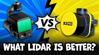
Is the DJI Zenmuse L2 LiDAR worth buying? (L2 vs R3 Pro V2)
Просмотров 9 тыс.Месяц назад
Dive into my comprehensive comparison of DJI's L2 and ROCK Robotic’s R3 Pro V2 LiDAR mapping systems as I test their abilities in an urban landscape. This video covers their technical specifications, flight plans, and real-world performance for professional mapping and 3D modeling. 🔗 www.rockrobotic.com/r3pro-v2 🔗 enterprise.dji.com/zenmuse-l2 Watch as I examine data accuracy, range, and detail...

LiDAR Mobile Mapping With The ROCK Mobile Mount
Просмотров 9892 месяца назад
Welcome to the official Unboxing & Installation Guide for the ROCK Mobile Mount! In this comprehensive video, we walk you through every step of setting up your ROCK Mobile Mount, ensuring a seamless integration with the SLAM Dock V2 and R3 Pro V2 LiDAR system. Whether you're mounting it on a car, boat, or any smooth surface, this guide provides detailed instructions and tips for a successful in...

I made a 3D model inside this building using ROCK LiDAR SLAM
Просмотров 6 тыс.2 месяца назад
Introducing: The NEW Colorized ROCK SLAM Dock V2!🤘 🔗 rockrobotic.com/slamdock-v2 🔗 rockrobotic.com/r3pro-v2 Join me in exploring the capabilities of the new ROCK SLAM Dock V2, featuring a 360 camera, GPS, and integration with R3 Pro V2 LiDAR for capturing beautiful Colorized SLAM 3D models. Watch as I transform a complex space into a detailed 3D model, create a Google Earth-like walkthrough, an...

The Best Mapping LiDAR (2024)
Просмотров 36 тыс.2 месяца назад
www.rockrobotic.com/r3pro-v2 Introducing the ROCK R3 Pro V2 LiDAR - The New Standard in Mapping! Dive into the heart of innovation with the ROCK R3 Pro V2, where precision meets efficiency in geospatial mapping. Our latest LiDAR masterpiece is not just an upgrade; it's a revolution designed to empower professionals across various industries. From surveying vast landscapes to intricate urban pla...

GPS is Changing and You Can Help
Просмотров 2,3 тыс.2 месяца назад
www.rockrobotic.com/rockbase www.geodnet.com Hey everyone! Welcome to our latest adventure into the tech universe, where we're zooming in on something super cool happening right now: a major GPS revolution! That's right, GPS isn't just for getting from A to B anymore; it's hitting its second major glow-up, and guess what? You're invited to be a part of this epic journey. Remember how GPS kicked...

5 Ways To Screw Up Your Drone LiDAR Data! (& How-To Fix Them)
Просмотров 3,1 тыс.3 месяца назад
In this video, I explore 5 common mistakes that can significantly degrade the quality of your aerial LiDAR data. But don't worry, I won't just show you what can go wrong - I will also guide you on how to correct these errors for PERFECT data collection. ℹ️ Visit www.rockrobotic.com to learn more about this LiDAR! Timestamps: 00:00 - Introduction to LiDAR data pitfalls 00:05 - Getting started wi...

Fixed-Wing vs. Multirotor Drone LiDAR
Просмотров 18 тыс.3 месяца назад
Fixed-Wing vs. Multirotor Drone LiDAR
Surveyor Questioned My Accuracy Video? (RESPONSE VIDEO)
Просмотров 3,1 тыс.4 месяца назад
Surveyor Questioned My Accuracy Video? (RESPONSE VIDEO)
Drone LiDAR Accuracy Demo (Bridge Inspection)
Просмотров 4,1 тыс.4 месяца назад
Drone LiDAR Accuracy Demo (Bridge Inspection)
Master LiDAR Data Processing (Full Walkthrough!)
Просмотров 9 тыс.9 месяцев назад
Master LiDAR Data Processing (Full Walkthrough!)
Mastering the Calibration Flight | R3 Pro
Просмотров 3,6 тыс.10 месяцев назад
Mastering the Calibration Flight | R3 Pro
Mission Planning Drone LiDAR w/ DJI Pilot 2 (M300 & M350 | R3 Pro)
Просмотров 4,8 тыс.11 месяцев назад
Mission Planning Drone LiDAR w/ DJI Pilot 2 (M300 & M350 | R3 Pro)
How-To Install and Pre-Flight Drone LiDAR | R3 Pro
Просмотров 1,5 тыс.11 месяцев назад
How-To Install and Pre-Flight Drone LiDAR | R3 Pro
How-To Process LiDAR Data: Complete Tutorial for ROCK Desktop (Pt. 1)
Просмотров 4,5 тыс.11 месяцев назад
How-To Process LiDAR Data: Complete Tutorial for ROCK Desktop (Pt. 1)
Intro to Drone LiDAR Hardware (ROCK R3 Pro Specs)
Просмотров 7 тыс.11 месяцев назад
Intro to Drone LiDAR Hardware (ROCK R3 Pro Specs)
How-To Fly Drone LiDAR | ROCK R3 Pro (Walkthrough)
Просмотров 415 тыс.Год назад
How-To Fly Drone LiDAR | ROCK R3 Pro (Walkthrough)
ROCK R3 PRO in Action: LiDAR SLAM at Shark Fin Cove
Просмотров 2,6 тыс.Год назад
ROCK R3 PRO in Action: LiDAR SLAM at Shark Fin Cove
Worlds best (2023) Drone LiDAR works in a Cave
Просмотров 45 тыс.Год назад
Worlds best (2023) Drone LiDAR works in a Cave
The Most Accurate Way To Capture 3D Data | ROCK R3 PRO
Просмотров 2 тыс.Год назад
The Most Accurate Way To Capture 3D Data | ROCK R3 PRO
Best LiDAR Drone in the World (2023)
Просмотров 206 тыс.Год назад
Best LiDAR Drone in the World (2023)
Is this the craziest land surveying story ever?!
Просмотров 432Год назад
Is this the craziest land surveying story ever?!
Man I wish I had enuf reason to purchase one of these but I live in the middle of no where alaska in front of a glacier, but man I would really love to have access to a system like this. Do you offer by the day rentals lol or by the week.
I have a experiment for you, find a gold miner that will let you scan there gold claim for free for the data scan resources.
Camera is only $28,000 on eBay
You are a liar. You did not complete a 1,200 acre UAV service job in 48 hours. You might have flown it in 48 hours (maybe); but you know you did not fly, geocode and classify 1200 acres in 48 hours.
I’m curious how much total the equipment cost to get into thisb
Super magnifique
So many negative comments people are so judgemental now
Probably because the person that paid 45k for 1,200 acres is pointing and laughing at him. I don’t know any UAV LiDAR service providers that would charge less than 150k for 1,200 acres.
Bro is a genius 🙌
Wow I know this is 3 years ago, but your statement has not been CORRECTED "How a LiDAR Drone Maps the Bare Earth through trees!" The earth for instance is not bare in a forest ,the bare earth is covered in fallen leaves branches etc, furthermore you imply Lidar sees THRU' vegetation ie in total. It is true it can get thru' voids. However Vegetation still has to be removed in the model and contours have to be extrapolated between reflected points. Lidar is great if correctly applied
We have to subscribe him
I would like to know the price of the R3pro V2
You get an "A" for enthusiasm but an "F" when it comes to properly explaining why I need this product. It's as if you think the only people interested in your content is a person with 10 years' experience. No one is expecting Drone LIDAR 101 but you make a whole lot of assumptions when discussing this technology. I think this is why your views and comments are so low. I studied computers and networking for years so I'm comfortable with tech talk, but several times I found myself not understanding the same benefits that you saw.
Any chance that you could comment on or make a video on shooting ground truthing points as checks for lidar surveying of a hydro corridor with high tension power lines (specifically from a helicopter if that makes any difference)? Not sure if any specific ground control points are being used or just our GNSS ground shots.
Do you have a number or email to ask many questions? I am brand new; I have flown drones a lot but not for commercial purposes. I am also working towards my Part 107 license. Please let me know; thank you.
So, is this a totally proprietary system?
interesting staff,pretty cool
wow, that was powerful
Many thanks for closing some potential knowledge-gaps at an upcoming job-interview of mine :)
Great breakdown. But pls explain the acronyms up front.
This not detail. It shows partials not whole process
will be just a big expensive paperweight if they ban DJI drones in the USA
Bud idea was....
What was your upfront investment on all of your gear for this project?
Can I get in touch with you re some advice/consulting for a TV series we're about to kick off with? It's an unusual application of Lidar/mapping and we need to decide on gear and a workflow in the field. TIA.
its great, we do not have such stuff in fiji
Quality content bro❤️🫶🏼
Oh boy, I wish I could work for someone like you. This is my dream job but at 38 I don’t know how I could make the switch. I fly drones myself and even created a business plan for a surveying and mapping company, using a friend who is a surveyor. That’s how passionate I am. But the friend had some issues and now I’m on my own.
What are the requirements to start flying and making money doing lidar mapping?
How much does a setup like this cost and what do you need in order to start flying and making money?
🙌👏
I'm Been Saving My Money With a $1,000 DJI Avata 2
That doesn't explain how you made $45000. For who? A company? Some research facility paid you? This explains nothing. Just a clickbait short. But the payload capabilities in drones are pretty cool.
Can you and I collaborate on merging this into a wearable?
This is pretty insane
but for what thing this data was used? Looks useless to me
What am I looking at here?
No you didn't
If you make so much money can i have $100 on cash app? It would take me all year to make $45,000
Hello! I would like to get in contact. I have a LiDAR & Survey Technician position open in Indiana and I am looking for experienced candidates to fill it. It could be a potential fit for some who came through your academy. Hope to hear from you soon.
Step one. Spend 40 thousand dollars 😂
Very well explained.. Thank you
what model camera? trying to zoom in...ROCK 53785A...
Looking good dude!
Well done, this was well thought out and communicated. I agree with your methodology. Maybe Alan's comment "can't get better than 4 inches" was simply a Freudian slip...😅
Hi, nice video. Is it rtk antenna around the insta 360 camera ?
Any precision is possible with unlimited money and resources . Heres a challenge: Use 1 or 2 smartphones and their video data out of a moving car and get the coordinates of trees at the street with a precision of 10 cm. Whats realy relevant is the relation between money + time + n-data points + precesion
Here's a really easy idea that nobody thought of.. Fly some moderately sized bit of interesting heavy canopied terrain, then go walk all over the place under the canopy. I'd sign up to watch that!
Can I do this in the UK?
Take care not to fall for flashy light syndrome....hardware is a moot point next to the software subscription pricing....
That’s why the rock software is affordable!
@@IndianaDrones Typically pricing that isn't openly displayed isn't affordable....
This looks like a Non-repetitive path scanning for L2. I'm not using it due to this kinda bad result. Total different story for the repetitive scan path, which is very accurate and precise even without smoothing and optimization. I'm super satisfied with my L2 unit in rep mode. I've noticed also a thing: i'm always using an Emlid RS3 set as base when using lidlar, with short baseline data precision increase drammatically, and also doing PPK. Your dataset looks acquired in worst condition possible.